Difference between revisions of "Digital Calculations for Payment"
m (Removed 2012 Spec Book tagline link) |
|||
| Line 4: | Line 4: | ||
==[[#Digital Calculations for Payment|Digital Calculations for Payment]]== | ==[[#Digital Calculations for Payment|Digital Calculations for Payment]]== | ||
| − | For determination of quantities, the use of survey equipment (Global Positioning System (GPS) receivers and total stations) and data collectors are becoming the preferred method for obtaining measurements for linear, area and volume calculations. All equipment used to make digital measurements must follow the standards for equipment and use as specified in the [https://mdotwiki.state.mi.us/design/index.php/Chapter_1_-_Survey_Standards_Introduction|MDOT Design Survey Standards of Practice]. The type of equipment used (total station, GPS, etc.) must be appropriate for the pay item and the applicable tolerance. The measurement method used for each pay item must follow subsection 109.01.B.1 of the [https://mdotjboss.state.mi.us/SpecProv/specBookHome.htm| | + | For determination of quantities, the use of survey equipment (Global Positioning System (GPS) receivers and total stations) and data collectors are becoming the preferred method for obtaining measurements for linear, area and volume calculations. All equipment used to make digital measurements must follow the standards for equipment and use as specified in the [https://mdotwiki.state.mi.us/design/index.php/Chapter_1_-_Survey_Standards_Introduction|MDOT Design Survey Standards of Practice]. The type of equipment used (total station, GPS, etc.) must be appropriate for the pay item and the applicable tolerance. The measurement method used for each pay item must follow subsection 109.01.B.1 of the [https://mdotjboss.state.mi.us/SpecProv/specBookHome.htm| MDOT Standard Specifications for Construction]. All terrain changes will be defined to appropriately represent the pay item, using the MDOT feature codes. |
In alignment with subsection 109.01.B, all pay items measured by horizontal measurements and all in place measurement items with terrain changes less than or equal to 7% must be calculated horizontally and can be done using the data collector or Computer -aided Design (CAD) software. | In alignment with subsection 109.01.B, all pay items measured by horizontal measurements and all in place measurement items with terrain changes less than or equal to 7% must be calculated horizontally and can be done using the data collector or Computer -aided Design (CAD) software. | ||
Revision as of 13:35, 26 July 2022
Digital Calculations for Payment
For determination of quantities, the use of survey equipment (Global Positioning System (GPS) receivers and total stations) and data collectors are becoming the preferred method for obtaining measurements for linear, area and volume calculations. All equipment used to make digital measurements must follow the standards for equipment and use as specified in the Design Survey Standards of Practice. The type of equipment used (total station, GPS, etc.) must be appropriate for the pay item and the applicable tolerance. The measurement method used for each pay item must follow subsection 109.01.B.1 of the MDOT Standard Specifications for Construction. All terrain changes will be defined to appropriately represent the pay item, using the MDOT feature codes.
In alignment with subsection 109.01.B, all pay items measured by horizontal measurements and all in place measurement items with terrain changes less than or equal to 7% must be calculated horizontally and can be done using the data collector or Computer -aided Design (CAD) software.
All volume measurements and items specifying measured in place that have terrain changes greater than 7% must be calculated on the three-dimensional slopes using CAD software. The format of the CAD files must be delivered in MDOT’s current CAD software version.
When project control exists, all points collected must be in the project coordinate system. When no project control exists, set a minimum of two check points and use GPS to establish State Plane Coordinates in the appropriate Michigan Zone. Measure the distance between check points with a total station to verify horizontal distance. Multiple pairs of check points may need to be established depending on the length of the project. At a minimum, control and check point verifications must be made at the beginning of every setup and before breaking down the equipment. All project control checks, and check point measurements must be stored as a point and delivered with the calculation attachments. All coordinate accuracies must be appropriate for the measurement method of the pay item.
If using a GPS receiver, a fixed Real-Time Kinematic (RTK) solution from either the MDOT Continuously Operating Reference Station (CORS) network or a local GPS base station must be used.
Digital measurements will be checked with all previous measurements to confirm there are no overlaps in payments. This may be accomplished by staking to previous measured points and beginning new measurements from those points. Overlaps may be justified depending on the type of work or project circumstances, for example calculations of wash outs after restoration is complete, seasonal grading, etc. It is recommended for the lead/senior inspector or project manager to coordinate the method of measurement either digital or non-digital for consistency in application to avoid overlap and potential overpayment circumstances.
Below are the specific requirements that must be followed for each payment measurement.
Survey Equipment
1. Total Stations, GPS, rods, tripods, tribrachs, targets and other equipment used should be inspected prior to use to ensure equipment is in proper working condition.
2. Maximum allowable error for Control/Check Point checks:
- a. Horizontally +/- 0.04 feet
- b. Vertically +/- 0.08 feet
3. Satellite availability on site may vary, when using GPS ensure 3D point quality is no more than +/- 0.08 feet when collecting data.
Horizontal Linear or Area Pay Item Measurement and In Place Pay Item Measurement with Terrain Changes Less Than or Equal to 7%
1. Points must be collected along the pay item in order to appropriately define the line or area:
- a. Collect points at all corners and deflections.
- b. Curves will be collected as a series of chords with sufficient points along the curve to accurately represent the curve.
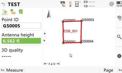
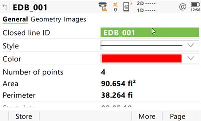
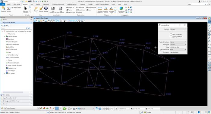
2. The following are examples of screen shots that must be attached to the Inspectors Daily Report:
- a. Map view of the line or area measured displaying the point numbers and chain name.
- b. Information screen displaying the calculated length or area of the pay item.
3. Export a comma delimited point file (CSV) or XML file of the pay item from the data collector to folder 208 in ProjectWise. File naming conventions will follow the Standard Naming Convention for Documents in the MDOT Construction Manual.
In Place Linear or Area Pay Item Measurement with Terrain Changes Greater Than 7%
1. Points must be collected along the pay item in order to appropriately define the line or area:
- a. Collect points at all corners, deflections, and changes in terrain break points.
- b. Curves will be collected as a series of chords with sufficient points along the curve to accurately represent the curve.
- c. Exterior boundary is defined.
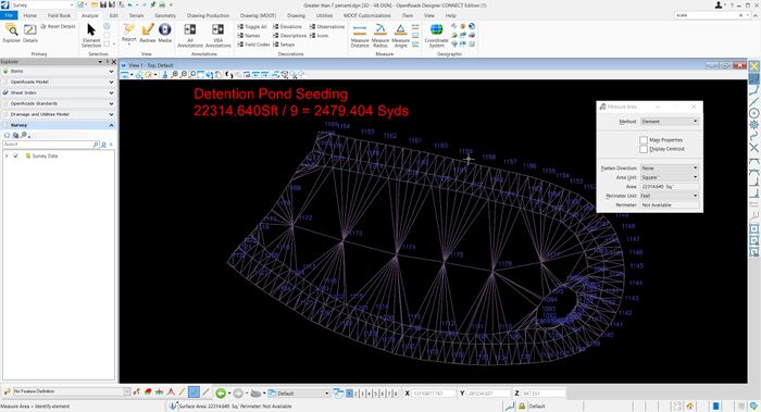
2. The following are examples of screen shots that must be attached to the Inspectors Daily Report:
Export the CAD and XML file of the pay item calculation including all points, linework and boundary used to define the calculation to folder 208 in ProjectWise. File naming conventions will follow the standard naming convention in the MDOT Construction Manual.
In Place Volume Pay Item Measurement
1. Points must be collected along the pay item in order to appropriately define the volume:
- a. Collect points at all corners, deflections, and changes in terrain break points.
- b. Curves will be collected as a series of chords with sufficient points along the curve to accurately represent the curve.
- c. Exterior boundary is defined.
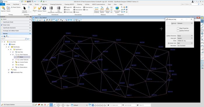
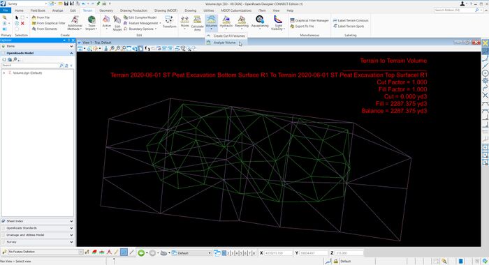
2. The following are examples of screen shots that must be attached to the Inspectors Daily Report:
- First Surface
- Second Surface
- Calculations shown between the two surfaces
3. Export the CAD and XML file of the pay item calculation including all points, linework and boundary used to define the calculation to folder 208 in ProjectWise. File naming conventions will follow the Standard Naming Convention for Documents in the MDOT Construction Manual.
