Chapter 2 - Data Requirements
By Chapter
2.1 Level of Detail Requirements
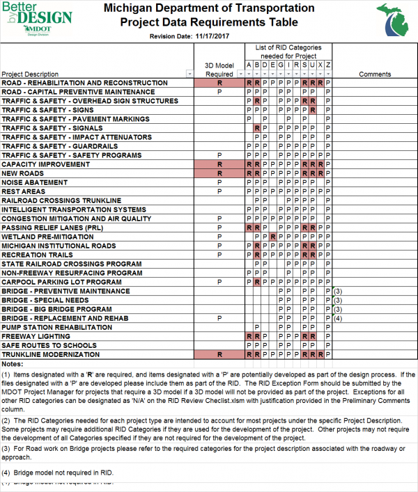
The Reference Information Documents (RID) process will require the inclusion of proposed 3D models for all projects as a general rule. Please refer to the Project Data Requirements Table.pdf document to determine the categories that are required for each project type (Project Description). The table is intended to capture the majority of the projects listed under each project description. At the discretion of the MDOT Project Manager some of the categories or RID files may be excluded based on the project parameters. For exceptions to all RID categories MDOT Project Managers can designated the RID category or File as 'N/A' on the Joint RID Review Checklist and Index.xlsm with justification provided in the Preliminary Comments column. MDOT RID Support will then review the exceptions with the Preliminary Submittal.
To help clarify the intent of when a 3D Model is required the following project types are generally excluded from this requirement:
- Log projects
- Standalone bridge projects
- Mill and fill projects
- Pavement patching and repair projects
- Crush and shape projects
- Projects without survey
Unless:
- There is wedging, widening, or earthwork for more than 1,000 feet
- The road elevation changes more than 3 feet
- The cross slope changes for more than 1,000 feet
- The superelevation or transition changes
- The improvements re-grade more than a total of 1,000 feet of ditch
- The improvements impact ROW
- The horizontal or vertical alignments change
The above lists are intended to be a starting point to help clarify the 3D Model requirements, and to convey the thought processes used to determine 3D Model requirements. We encourage design teams to provide input as they work through unique and challenging situations.
2.2 Software Requirements
2.2.1 MDOT Workspace
For consistency and uniformity MDOT provides the following two CADD workspaces for free download.
MDOT_02 Workspace
- This workspace requires Power GEOPAK SS4 or MicroStation SS4 + GEOPAK Civil Engineering Suite SS4.
- The workspace no longer supports SS3.
- The MDOT_02 Workspace is available for download by consultants at the following link:
- http://mdotjboss.state.mi.us/SpecProv/trainingmaterials.htm
- Go to All - Software and Workspaces.
- Consultant installation instructions are located in the “M:\MDOT_02 Workspace\1_Install†folder.
- The MDOT_02 Workspace install procedure supports the following applications:
- a) Power GEOPAK SS4
- b) MicroStation SS4 + GEOPAK Civil Engineering Suite SS4
- c) Stand-alone MicroStation SS4
MDOT CONNECT Configuration
- This configuration is required for all new projects started after October 1, 2020.
- The MDOT CONNECT configuration is available for download by consultants at the following link:
- http://mdotjboss.state.mi.us/SpecProv/trainingmaterials.htm
- Go to All - Software and Workspaces.
- Consultant installation instructions are located in the “MDOT Connect Configuration Install\†folder.
- The MDOT CONNECT Workspace install procedure supports the following applications:
- a) OpenRoads Designer CONNECT Edition
- b) OpenBridge Modeler CONNECT Edition
- c) Microstation CONNECT Edition
- If you are in the early stages of a project started using the MDOT_02 Workspace and need assistance with upgrading of survey & design data for use with the MDOT CONNECT Configuration, please contact MDOT-CADDSupport@michigan.gov.
2.2.2 MDOT Road Design Software Requirements
In order to provide consistent, uniform deliverables MDOT designers must utilize the current MDOT accepted version of Bentley products. Please note that any of the software applications below are compatible with the applicable workspace:
| MDOT_02 Workspace | MDOT CONNECT Workspace |
|---|---|
| Civil Suite SS4 Update 3 - (081109903en.exe) | OpenRoads Designer 2020 Release 2 (ord10080133en.exe) |
| MicroStation_SS4 - (081109832en.exe) | Microstation CONNECT Edition Update 13 (ms10130101en_updt13.exe) |
| Power GEOPAK SS4 Update 3 - (081109904en.exe) | |
| Survey Only - Power GEOPAK SS4 Update 3 - (081109885PB.exe) | |
| Civil Suite SS10 (gkste081109918en.exe) | |
| MicroStation SS10 (ms081109912en.exe) | |
| Power GEOPAK SS10 (pgk081109918en.exe) |
This software must be used in conjunction with MDOT’s current Workspace or Configuration. Refer to Section 2.2.1 MDOT Workspace.
2.2.3 MDOT Bridge Design Software Requirements
In order to provide consistent, uniform deliverables MDOT designers must utilize the current MDOT accepted version of Bentley products.
| MDOT_02 Workspace | MDOT CONNECT Workspace |
|---|---|
| See section 2.2.2 | OpenRoads Designer 2020 Release 2 (ord10080133en.exe) |
| Microstation CONNECT Edition Update 13 (ms10130101en_updt13.exe) | |
| OpenBridge Modeler Update 8.1 (obm10080245en.exe) | |
| OpenBridge Designer Update 8.1 (brges10080130en.exe) | |
| ProStructures Update 4 (ppst10040047en_updt4.exe) |
2.2.4 MDOT Drainage and Utility Design Software Requirements
-Reserved-
2.3 Digital File Formats
Electronic Data is to be delivered in the following digital file formats:
| File Type | MDOT Delivered Format |
|---|---|
| CAD Graphics (2D & 3D) | .dgn (MicroStation / Power GEOPAK design file) |
| Survey Control Coordinate Files | ASCII .txt |
| Alignments (Horizontal and Vertical) | .xml |
| Existing & Proposed Surface Data | .xml |
| Cross Section Data | .dgn and .pdf |
| Reports | |
| Project PDF submittals (Only for designated Project PDF jobs) | |
| Removal and Construction Quantity files (Only for designated Project PDF jobs) | .kmz |
| Photographs | .jpeg |
Table 2.3.1
2.4 Guidelines for Plan Preparation
| Move proposal : This Section has been moved to Chapter 7 - Plan and Proposal Preparation. |

